研究テーマ | Research theme
UAVを用いた簡易型水域環境計測システムの開発
Development of Water Environment Measurement System by means of UAV
研究者 | Researcher
研究概要 | Research summary
河川や湖沼などの水域環境の管理・保全には,河道・湖盆・水深などの形状情報や栄養塩・植物プランクトン・SSなどの水質情報の取得が不可欠です。それらの情報を定期的に取得することは,コスト的に非常に困難です。そこで,UAVで空撮した写真画像から,簡易的に水域環境情報を計測するシステムの開発を行います。UAVを用いることによって簡易的に,短時間のうちに広域な情報を取得することが可能となります。
In order to preserve water environment like as river and lakes, it is necessary to obtain the information of shapes and water quality. However, it is very difficult to obtain adequate qualitative and quantitative datas regularly because of its cost. Therefore, we developed the simple water environment mesurement system by means of UAV. This system make us possible to obtain the water environment information widly and simply in a short time.
特色・研究成果・今後の展望
- 同時に広範囲の水域の環境情報を取得できます。そのため,水質測定における時空間的な誤差を最小限に抑制できます。
- 堤体・堤防・堰などの劣化を自動的に抽出することができます。
- UAVを用いることにより衛星画像を利用した場合と比べ,高精度・高分解能な水域環境情報の取得が可能であり,天候の影響が比較的少ないです。そのため,定期的な計測だけでなく,災害発生直後に水域劣化個所の抽出が可能となります。
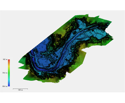
水深補正後のDEM
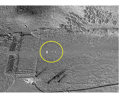
堤防クラックの自動抽出
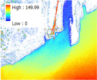
SSの空間分布(推定値)
社会実装への展望
水域の形状や水質情報の取得が大幅に簡易化することができるようになります。自動的に空間変異を抽出することができ,災害直後などに危険個所を迅速に発見し復旧支援が効率的に行えます。さらに,水質分析設備が整っていない発展途上国等における水環境管理に大いに活躍できると期待されます。
企業への一言メッセージ
水質推定には,まだまだ課題が残っています。一緒に研究・開発をしてみませんか!?